Showing posts with label Erie Canal. Show all posts

Sunday, January 26, 2025

Michigan's Struggle for Statehood

The British officially turned over Fort Detroit to the United States and evacuated on July 11, 1796. At noon, the Union Jack was lowered and the American flag was raised. Michigan was officially part of the United States under control of Territorial Governor Arthur St. Clair.  

On July 13th, United States Colonel John Hamtramck arrived with 400 soldiers to secure the Detroit command. Detroit consisted of a wharf, a fort, and a citadel of about 100 houses, shops, taverns, and Ste. Anne's Church. Ribbon farms extended on both sides of Detroit from the St. Clair River up stream to the Rouge River downstream.

The first United States Federal Census in the Michigan Territory was in 1800. Detroit's numbers were so small that they were lumped in with Wayne County's numbers. It was estimated that 500 people lived within the stockade with another 2,100 living on nearby farms. 

In 1810, the first Michigan Territorial census counted 770 people living in Detroit while the rest of Michigan territory showed a population of 4,762. With a combined population over 5,000, Michigan was entitled to three seats on the Northwest Territory's legislature. By 1815, Detroit was incorporated as the City of Detroit with its own governing board.

Population growth was slow in Michigan because the Surveyor-General of the United States issued a faulty land report based on flawed and incomplete information that the territory was nothing but lakes, swamps, and sandy land. Most settlers hoping to homestead farmland out West opted to follow the Ohio River water highway to Ohio, Kentucky, Indiana, Illinois, and Missouri. The erroneous account delayed Michigan's development.

The inaugural trip of the steamship Walk in the Water, named after a Wyandot tribal chief, left from Buffalo, New York for its destination of Detroit, Michigan in 1818. This marked the beginning of regular steam service carrying passengers and goods between the East and Detroit. Steamship travel on Lake Erie opened up Michigan and the Great Lakes area for farming, timber, and mining interests from New York City. 

The 1820 census showed Detroit's population to be 1,442 while Michigan's population grew to 8,927. Government-funded post roads were built radiating from Detroit helping to develop small towns and farming communities inland. On a public safety note, City Fathers erected a public whipping post near the intersection of Woodward and Jefferson avenues to discourage petty crime and drunkeness. It remained in use until 1831. As a result of the Greek War for Independence, 1822 saw a huge influx of Greek immigrants to the Detroit area.

Travelers headed to Buffalo, New York.

The United States' second wave of immigration consisted mostly of Irish and Germans. Many of these newcomers constructed the Erie Canal between 1817 to 1825. The Irish with horses and mules dug 363 miles of canal while German stonemasons engineered bridges and built thirty-six locks that raised freight boats and other canal traffic 565 feet in elevation from east to west. When the canal opened on October 26, 1825, it set off a land boom in Michigan and Detroit until 1837.

The 1830 census of the Michigan Territory counted 85,000 people which qualified Michigan for statehood. There was a delay because of the Toledo Strip dispute with Ohio in 1835. This was the original Buckeye/Wolverine rivalry. The so-called Great Toledo War was a stalemate settled with ink rather than blood.

Michigan was admitted to the Union on the condition that the Ohio boundary be accepted. Ohio got the Toledo Strip and Michigan got the entire Upper Peninsula with some of the most gorgeous and extensive lakefront property in the United States. Statehood was granted in 1837. 

Michigan soon adopted its state seal and motto designed by Lewis Cass in 1835. The bald eagle symbolizes the United States, while the elk and the moose holding a shield symbolize Michigan, with the Latin word "Tuebor" meaning "I will defend." The state's motto is "Si Quaeris Peninsulam Amoenam Circumspice" (If you are looking for a beautiful peninsula, look around you), all on a field of dark blue.

Erie Canal Populates the Great Lakes Region

Sunday, April 8, 2018

Erie Canal Populates the Great Lakes Area

If you wanted to travel to the Northwest Territory from the East prior to 1825, your choices were limited to canoeing with portaging around sizable natural barriers, or a person could take a rugged land passage on horseback or a horsedrawn wagon over perilous dirt roads and Indian trails. Neither method was suitable for commercial success or serious westward expansion. There needed to be some way to open the interior of the continent west of the Appalachians to farming and settlement.

The driving force behind the Erie Canal was New York Governor DeWitt Clinton. His vision made Detroit a destination city in the nineteenth century and provided a water highway for many of our European ancestors--especially German, Irish, Italian, Polish, Scandinavian, and Greek. These settlers were not like the French who trapped and hunted wildlife establishing a lucrative fur trade with Canada and Europe. These new immigrants were land-hungry farmers and empire builders who wanted a fresh start in life, and they changed the face of the Great Lakes region forever.

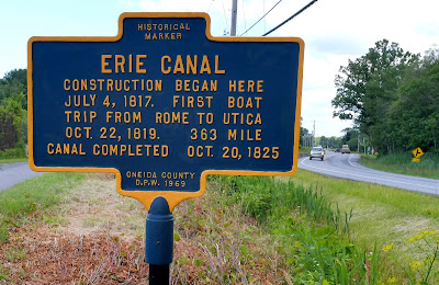
Once Governor Clinton raised the seven million dollars for its construction, the groundbreaking for the Erie Canal began at a middle segment of the proposed route in Rome, New York, on July 4, 1817. When finished, the canal would stretch 363 miles from Albany, New York on the Hudson River to Buffalo, New York on the east end of Lake Erie, opening the Great Lakes to westward American expansion.

Untold numbers of Irish immigrants and draft animals provided most of the muscle power to dig out the canal. The excavated soil was piled on the north side and graded to form a towpath for horses to pull canal boats and barges along the route. Hundreds of migrant German masons were hired to build the stonework for thirty-four locks needed to raise the boats 565 feet--the elevation difference between the Hudson River and Lake Erie. Where the canal had to cross valleys and water barriers, the masons built eighteen aqueducts to carry the boats above them. 


Lockport, New York
In 1823, the builders reached the Niagara Escarpment at what came to be known as Lockport, New York. Canal engineers devised five locks along a three-mile stretch to carry the canal eighty feet over the dolomitic limestone barrier. The original Erie Canal profile was forty feet wide at the surface, twenty-eight feet wide at the bottom and four feet deep. In 1835, the State of New York enlarged the canal to seventy feet wide and seven feet deep, further encouraging westward expansion and making New York City the economic powerhouse of the Eastern Seaboard.


"Erie Canal Opening" by Charles Yardley Turner (1905).
The Erie Canal was completed in eight years, two years ahead of schedule at a cost of $7,143,000. In a grand ceremony, Governor Clinton and other dignitaries boarded the Seneca Chief steamer in Buffalo and traveled the length of the canal to the Hudson River and down to New York harbor. On October 26, 1825, amid patriotic fanfare and a brass band, Governor Clinton took a keg of Lake Erie water and poured it into the Atlantic calling it a "marriage of the waters." The keg was then refilled with ocean water for the return trip of the Seneca Chief to Lake Erie to consummate the exchange of water.


Erie Canal aqueduct
The Erie Canal became an instant commercial success and stimulated economic growth along its entire route. Before the canal, the only way west through the Appalachian Mountains was overland on rugged wagon roads. The trip to Detroit took five to six weeks. The Erie Canal cut that time in half.

Prior to the canal, bulk goods traveled on the backs of pack animals limited to no more than 250# per beast of burden. Canal boats could carry up to thirty tons of cargo. Shipping costs dropped 90% from $100/ton to less than $10/ton. Buffalo, New York became a major transhipment point for farm produce from Ohio, Indiana, Illinois, and Michigan going east while manufactured goods and European immigrants shipped west.

Historian Harvey C. Colburn wrote in The Story of Ypsilanti (1923) that "Immigration in Detroit from Europe was greatly facilitated by the Erie Canal. The first steamer on Lake Erie was the Walk-on-the-Water in 1819. By 1826, there were seven steamers on the lake, and by 1830, a daily service was established between Buffalo and Detroit." If your ancestors came to Detroit between 1825 and the 1850s, chances are they floated up the Erie Canal courtesy of the labor of thousands of skilled and unskilled immigrants who preceeded them.

The Erie Canal reconfigured the young United States' national religious and social dynamics by connecting the Hudson Valley with the Great Lakes region. By 1842, the New York Railroad had a continuous line linking the East with the continental interior. Passenger traffic on the canal tapered off in favor of the modern steam locomotives with their speed and relative comfort. The canal simply increased its commercial freight business. Water was still the most cost-effective way to move bulk goods, and the canal could ship thirteen times more tonnage than all the trains of New York Central Railroad.


By the end of the 1880s, railroads dominated passenger transportation, but it wasn't until competition from improved roadways and the trucking industry at the beginning of the twentieth century that the canal was rendered obsolete. Today, 200 miles of the old canal are used for public recreation like boating, biking, hiking, and cruising.


https://www.cbsnews.com/news/all-hail-the-erie-canal-200th-anniversary/